City
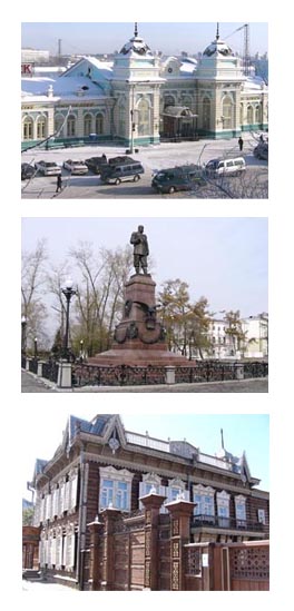
Irkutsk
Irkutsk is popular not only because it is situated very close to lake
Baikal (6o km or 36 mls) but because it has a magnificent historic
heritage. Like all Siberian cities Irkutsk appeared on the map of Siberia in the XVIIth century. It started from the wooden fortress
built in 1661 on the 6th of July by Russian Cossacks led by Jakov
Pahabov. The Irkutsk fortress was considered to be a very important
strategic point in the East of the country. That's why it was strengthened and armed much better than others in Siberia. It grew
rapidly; in 1686 it got the status of the city.
 The city developed a lot in the XVIIth century. The travelers of that
time admired the great number of Churches. There were 13 churches in the XVIIIth c. And before the Great October Revolution of 1917 there
were nearly 40 churches and cathedrals. Irkutsk by the number of the religious buildings ranks first among the Siberians cities. By now one can see churches of different religions. Orthodox, Roman-Catholic
churches, Muslim mosque and Juddish synagogue coexist peacefully in Irkutsk.
The city developed a lot in the XVIIth century. The travelers of that
time admired the great number of Churches. There were 13 churches in the XVIIIth c. And before the Great October Revolution of 1917 there
were nearly 40 churches and cathedrals. Irkutsk by the number of the religious buildings ranks first among the Siberians cities. By now one can see churches of different religions. Orthodox, Roman-Catholic
churches, Muslim mosque and Juddish synagogue coexist peacefully in Irkutsk.
Irkutsk has always attracted merchants, travelers, diplomats and religious missions with its location (close to lake Baikal) and architectural design. The city was supposed to become the «window
facing East», as it stands on the way to the Pacific Ocean. Al expeditions, organized by the Russian government to the Far East,
Mongolia, China, Alaska were formed in Irkutsk. First Ambassadors to Beijing went through the city, trade caravans — to and from Mongolia,
China and America stopped in Irkutsk for some nights and for the provision. Wholesale of eastern Siberia was mostly maintained by Irkutsk merchants.
The first records of Irkutsk as a place for exile were found in Gingis-
Khan's service regulations: there were two methods of punishment for his soldiers — capital punishment and exile to Siberia (many preferred
the first better). In the end of the XVIII- beginning of the 20th
centuries Siberia was always associated with exile. By the end of the XIXth century there was one exiled person per two civilian Siberians.
In this region used to live political, religious dissidents and just
criminals. Among them were Decembrists, Polish exiled nobility,
Bolsheviks. The majority of them were noble and aristocratic people who did not support tsarism. The exile to Siberia had a great influence on the cultural and scientific life of the locals. Thanks to them Irkutsk
was turned into the cultural and spiritual center of Eastern Siberia.
Among 80 first revolutionaries, sentenced to the exile by the Tsar's
edict, 40 were exiled to Irkutsk region. The most outstanding of them
are N.M. Muraviev, S.P. Trubetskoi, S.G. Volkonskyi, M.S.Lunin,
V.F.Raevskyi, N.A.Panov, A.I.Odoevskyi. Some Decembrists' wives
followed their husbands in exile, relinquishing everything they had,
including children.
Even in the XXth century there were 20 000 exiled in the Irkutsk
region. Before the revolution of 1905 there were 6 635 political
dissidents in Siberia. After the revolution in 1907 — nearly 74 275.
A great role in the development of Irkutsk as a city played the decision of Russian emperor Alexander III to build the Trans Siberian
railway. To commemorate the completion of the Railway construction two monuments to Russian Tsar Alexander III were erected in St. Petersburg
and Irkutsk. The Emperor was depicted as a Cossack's chieftain looking
to the East.
Before the construction of the Irkutsk hydroelectric power station the Circum Baikal railroad was a part of the Great Trans Siberian railway.
A sector of the Circum Baikal rail road was flooded but nowadays it can really be called «the longest museum in the world». It is a magnificent
monument devoted not only to the skill of numerous engineers of the beginning of the XXth century, but also to the unique and breathtaking
scenery of this area: geology, mineralogy and zoology.
The most famous exiled were Stalin (1903 in the village Novaya Uda).,
F.E. Dzerzhinski, M.V. Frunze, V.V.Kuibishev, V.M.Molotov,
G.I.Ordzhonekidze. In 1945 600 000 Japanese soldiers were captured in Manchzhuria and were brought into Siberian and Russian Far East
concentration camps. Only in Irkutsk district there are more than 80 cemeteries.
Being the place of exile and a frightening word for a lot of Russians,
Irkutsk design on the contrary is quite beautiful. The architectural
style of Irkutsk was built-up on the contrast of one-two storied wooden
buildings and huge churches. A great disaster for the city was the Great Fire in 1879 on the 22 of July. 105 stone and 3438 wooden
buildings, 11 churches, the Geographical society's library were burnt
down. The biggest part of the center was destroyed by the fire as well.
Among the central streets only one was saved — Arsenalnaya street (
Dzerzhinskaya now). The fact that the hugest bell of the Epiphany
cathedral melted in the fire testifies how terrible and big the fire
was.
After the Great Fire a new stone city emerged, the construction of the wooden houses was mostly forbidden especially in the center.
Nowadays Irkutsk with a population of 600 000 people is a big industrial and scientific center of Eastern Siberia. In 1970 Irkutsk
got the status of a city museum because there is still a lot wooden
houses of the XVIII-XIXth century well preserved till nowadays. Among
Siberian cities Irkutsk and Eniseiisk were included into 115 cities
which were recognized as historic. There are more than 500 architectural monuments in Irkutsk, architectural styles of which
represent different historic epochs of Russia. The most interesting and impressive place in the terms of history is the center of the city -
the place of its foundation. This is the only city in Russia which has 3 (original) churches in one square.
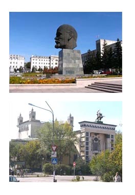
Ulan-Ude
The city of Ulan-Ude is situated in the western Zabaikalie, 100 km (62
mls) to the east of Baikal, at the cross point of two rivers: the Selenga (flows out of Mongolia and flows into lake Baikal) and the Uda,
surrounded by 3 mountain ranges: Khamar Daban and Ulan-Burgasy in the north-west; Tsagan-Daban in the south-west.
The history of the city is dated back to the times when the Russian
army explored Zabaikalie, the land of indigenous people — «buryats» in the 17th century. Not only Cossacks were attracted by this land, gold
miners, merchants, peasants and farmers came to try their fortune here
as well. The exploration of Zabaikalie was mostly connected with
valuable expensive furs of different animals; furs were at that time
the best income to the state budget, played an important role in import
and export of Russia.
 The explores mostly came to this land to collect the tax from the locals. But not all of the indigenous tribes obeyed and the Russian
army soldiers had to build fortresses to defend themselves from the locals. Ulan-Ude was originally founded as such a fortress — called
Udinsk at first, which became an important strategic and economic place
as well as it was situated at the junction of two rivers Uda and Selenga.
The explores mostly came to this land to collect the tax from the locals. But not all of the indigenous tribes obeyed and the Russian
army soldiers had to build fortresses to defend themselves from the locals. Ulan-Ude was originally founded as such a fortress — called
Udinsk at first, which became an important strategic and economic place
as well as it was situated at the junction of two rivers Uda and Selenga.
The town became bigger and bigger by the 18th century, two-storied
buildings with huge windows appeared. The first stone construction in the city is Odigitry Cathedral (1741-1785, in Banzarov sq.), it is the only example of Siberian baroque style survived by now.
Starting from 1780 a lot of fairs were organized in the city. They were
held twice a year- in winter and in summer and soon became very popular
all over Russia: in Nerchinsk, Kyahta, Irkutsk, Nizhnii Novgorod,
Moscow. The Russian government realized the importance of the city as a trade center and in 1783 it was given the status of the capital of Zabaikalie.
Verhneudinsk (the second name of the city) became a part of the developing Russian market. Workshops and factories were built soon.
Even though industry developed slowly the population was growing from
year to year.
The stone structure Trade Rows built on the money of merchants in 1830
in the center of the city is one of the best architectural designs (classicism).
The Great Fire in 1878 destroyed most of the buildings mostly storage
houses for firewood, cattle, hay. But in two years the citizens rebuilt
many of them.
The construction of Trans-Siberian railroad in the beginning of the 20th century contributed to the prosperity of the city as well as to prosperity of Siberia and Russian Far East. A big steam locomotive
deport was built in the city in 1900. First electric station was built
in 1908. In 1912 the industry was represented by glass making factory,
brewery, sawmill, distillery, brick making factory, soap works and four
steam mills. There were two printing houses, Russian-Asian bank
department, a post office and a telegraph.
A lot of events happened in Verhneudinsk in 1905 — the beginning of Russian-Japanese war was one of them. Strikes and rebellions were
organized in the city. The Great October revolution, Civil War (1921-1923) and intervention is a part of the city's history as well.
When the Soviets came to power in 1923 Verhneudinsk was proclaimed the capital of Buryat-Mongol Republic.
The establishment of the Soviet regime caused the growth of the population in the city because new administrative, political and public
organizations were founded in Ulan-Ude.
Today the city is developing as an important industrial,
administrative, trade, educational and cultural center of Zabaikalie.
Thanks to its advantages geographical location, at the junction of the roads, connecting the west and the east of Russia, the city became a big transportation line and «the main tourist gates» of Buryatia at the same time.
Severobaikalsk
North littoral of Baikal is getting more and more attractive to the tourists. Unforgettable impressions are made by luxuriously panoramic
sights of Baikal which are framed by snow-covered mountains, great
landscapes, fresh air, crystal-clear and limpid water. You can find
here tranquility and pacification.
It is harsh beauty of the northern nature that yields a flavor to Severobaikalsk — the Capital of Buryat sector of the Baikal-Amur
Railroad. Situated among the mountains and Taiga, the town is harmonically joined to the landscape. It has an original architectural
shape and its own style. Sense of range are made by wide avenues,
beautiful railroad station and central square of the town. But the main
richness of it is people who are the patriots and judges of themes land.
The feature of the Town is that there are a lot of small comfortable
hotels, exclusive bars, cafes, restaurants with traditional Buryat,
Russian and good European cuisine with high quality of service. There
are a lot of possibilities for active and cognitive relaxation.
The museum of the Baikal-Amur Magistral (founded in 1978) — one of the youngest museums of Siberia — is offering an informal exposition. It includes great materials on construction of BAM to the north of Baikal.
The museum has documentary photographs since 1967 till nowadays, rare
books, archeological, ethnographical and other exhibits.
Picture-gallery was founded in 1979 in Severobaikalsk. The collection
consists of pictorial linens of modern artists of Russia. There are some ceramics and porcelain wares in the part of arts and craft.
We are sure that no one will deplore and more, you will be fascinated
with originality of northern part of Baikal and will never forget of the hospitality and kindness of the citizens
Kyakhta
«Kyachta» comes from Buryat «wheat grass» — wheat grassy district.
Kyachta advanced post was founded in 1728 by Russian ambassador Sava
Lukich Vladislavich-Raguzinskiy, who came here by representation of Peter I and Ekaterina I to sign the border treaty with China. A merchant large village with private residences of honorable citizens of Kyachta was built there. There were wooden custom waterhouses, later -
made of stone. Kyachta was famous as the golden gates of Russia. Tea was brought from the East. The Great Silk Way stretched through Central
Asia, the Great Tea Way — through Kyachta.
Near this large village, near Troitsk fortress, a large city started to grow, where people of all social layers lived. A hundred years later it turned into the most important city of Transbaikalia. It got name after
Troitsk fortress and its founder Sava Raguzinskiy — Troitskosavsk.
The first stone buildings appeared in Kyachta in the XIX century. There
was Troitsk cathedral in the center of the city, Voznesensk church in Kyachta large merchant village (an architectural masterpiece of Italian
architects). It is called «music stiffened in stone». It was closed in the 30s of the XX century. But tourists still admire it. There is Uspenskaya church (1884) in Byzantian style, a monument of Russian cult
culture of the XIX-th, on the old cemetery that was built on the money
of a first guild merchant Y. A. Nemchinov.
«The Golden Gates of Russia» began loosing its meaning with the foundation of the Suez channel in 1890 and with the Transsiberian
railway. Kyachta-Troitskosavsk with its 50 firms lost its status in the XX century.
The building of Gostinniye Ryadi in Troitskosavsk (1847-1853), a two-storied stone building, belongs to the years of Russia-China
trade's bloom. It undergone restoration in 1977 and now «Gostinniye
Ryadi» decorates the center of the city.
In the beginning of the XIX century Kyachta-Troitskosavsk turned not only into a business center but into the center of social and cultural
life of Transbaikalia. In cultural sense it was higher than
Verkhneudinsk and Chita. It was called «Sandy Venice“.
In the end of the XIX century and in the beginning of the XX century
Kyachta was the most influential city of Transbaikalia. On the 11th of August 1934 Troitskosavsk got its new name — Kyachta.
Kyachta district is rich in archeological monuments. The monuments of Huns period are kept here.
Kyachta Museum of Regional Studies is on of the oldest museums in Siberia. It was founded in 1890. In its rooms you can see exhibits of unique collection that were gathered by the members of the local
affiliation of the local geographic society: by teachers, merchants,
doctors, scientists.
Among all the collections a significant place is occupied by the archeological collection.
In the rooms of Nature section you will get acquainted with its amazing creatures.
In the room of Geographic discoveries you will see evidences of Great Central-Asian expeditions, which traversed Kyachta.
Artistic works of Buryat, Mongolian, Chinese and Japanese masters will enchant you with their diversity and elegance.
Remarkable book collection of the museum includes unique collection of XVIII-XIX centuries.
For centuries of its existence Kyachta has become known far beyond the borders of the republic. Come and see it. It's always glad to welcome
guests.
Krasnoyarsk
All who visited Krasnoyarsk were impressed with hospitality and great
generousity of the citizens; their pride and a feeling of self-esteem,
familiar attitude to the local officials. You will be enchanted by the strong Yenisey and borderless taiga, stepping close to the city.
Yenisey, like a wide band, makes a borderline between notrh and south
of Krasnoyarsk. It’s the most powerfull river in Russia, where the water level is the highest. It takes the beginning in the very heart of the Aisan continent from two mount rivulets Biy-Khem and Ka-Khem, from
the Sayan Mountains. Through Khakass steppes Yenisey comes to Krasnoyarsk as a strong hard-working giant. Enchanted with the beauty
of the Siberian river, a great Russian writer Anton Chekhov wrote in one of his essays: “… never ever in my life I saw a more magnificent
river than Yenisey. Strong and furios warrior, who doesn’t know where
to apply his power and youth…“
Krasnoyarsk was founded by Andrew Dubensky as a fotress, a srong point
for the Russians to strengthen their positions on the Middle Yenisey in 1624. From the first days of its life Krasnoyarsk had to use both
weapon and diplomacy to establish his right for existance in struggles
and wars with the Kirgiz princes, that ended only in the beginning of the XVII.
As the garrison since the beginning of the XVIII grew bigger and bigger, Krasnoyarsk became one of the biggest Siberian fortresses (849
people in 1708). Material and spiritual culture of the Russian people
in Krasnoyarsk and whole Siberia was developing as a variant of North
Russian culture. Everyday life of the people had its peculiarities. Fur clothes (coats, hats, shoes, mittens), Chinese cotton and silk shirts,
belts, pinafores and shawls were found here more often than in the european part of Russia. Northern people were heavy eaters of game and fish; they used wooden and china dishes more ofthen than clay ones. By the last quater of the century the image of the city ceased to remind
the citizens and the guests about the military past. A terrible fire of 1773 left only 30 houses in the city and destroyed all fortifications.
As Moscow Siberian tract was laid, the city got an important position
on the crossroad of the Siberian both land and water way. Thanks to this central position in Siberia and diverse flora and fauna of the Yenisey basin, Krasnoyarsk became the strong point for many scientific
expeditions of XVIII.
Today Krasnoyarsk is the administrative center of the Krasnoyarsk
region. The population of the city is about 900 thousand people. This
is an important industrial, scientific and cultural centre of Siberia.
If you want to surprise your guests, invite them to the Krasnoyarsk
Museum of Local Studies – the gem of Siberia, which being 112 years old was acknowledged to be the best provincial museum of Russia in 2001.
There you can see the elements of the Siberian ancient times and also
real satellite of the Earth, constructed on one of the local plants,
which is responsible for the output of 70% of all cosmic industry in Russia.
Have a look at Russian ten rouble note. There you can see the Chapel of Paraskeva the Friday (1855). It appeared in your hands as an invitation
card to this biggest city on the banks of the Yenisey. From the observation tower of the Chapel you can get a panoramic view of the whole city with its gilded domes and crosses of Krasnoyarsk churches,
with its wonderful natural surrounding.
It is really wotrh while visiting Divnogorsk. The city appeared as a settlement of Krasnoyarsk Hydroelectrostation workers in 1957. The city
got its name from splendid mountains surrounding the city (“Divny“ in Russian means “wonderfull“, “splendid“; “gori“ – mountains). The main
principle of the city construction is green terasses, coming down to the prettiest embankment. From this place you can see the famous Monk
Rock, on the opposite bank of the Yenisey.
As for nature and hiking lovers, they are always welcomed in “Stolby“
reserve. This very place was call the Eighth Wonder of the World, being
first among such masterpieces of nature as Kizhi, Baikal, “Golden Ring“
and Suzdal Kremlin. If you happened to visit Krasnoyarsk, but didn’t
manage to get to “Stolby“, you haven’t seen the heart of the city, its lungs, its soul. Millions of years rains and winds carved out of savage
stone these gigantic sculptures. The stone figures share the sense of eternity and primeval times. The height of some rocks reaches 120 metres. But the main thing to mention is the unrepeatable beauty of silent giants, standing in the centre of Siberian taiga from the time
of the Creation.
Novosibirsk
Thinking about ways of a vivid picture creation by means of written
word, I refer to this metaphor of Novosibirsk being hodge podge – there
are bits and pieces of everything in it. Say, etymologically the meaning of Krasny Prospect (the city main street, runs straight 6,5 km)
can be traced back both to communist time: “krasny“ means “red“ in Russian and is the colour of Communist party; still, if we look further
into the history of Russian language, we will see, that in Old Russian
the word “krasny“ also had the meaning of “beautiful“. Thus, Krasny
Prospect might also be interpreted as “a beautiful street».
During its 112-year-old history Novosibirsk changed its name several
times. Initially, there was a small village of 5 houses called
Krivoshekovo; the construction of Trans Siberian Railway at some point
brought Alexander III on an inspection tour, which resulted in his donating money for Alexander Nevsky Cathedral construction and consequent renaming of the village into Alexandrovsky. 1898 brought an idea of changing the name into Novonikolaevsk (logically, Nicholas II overtook the throne some time earlier) in an attempt to get a city
status and, thus, more money from the country budget. The Great October
Revolution thunder rolled to the remote parts of the country slowly. 8 years after the Tzar family were massacred in Yekaterinburg the new government found out a city named after the Tzar in the very heart of the Red Empire. Novonikolaevsk was erased from the map – still, it took
some time for the brave new world to think of a new name. There were
such ideas as Vladlen (contracted from Vladimir Lenin – the communist
leader), Krasnooktiabrsk (Red October), Krasnoobsk (Red Ob (the river
on which the city stands)). They ended up picking a version proposed by a school boy – Novosibirsk (New Siberia). To think that this was the final name change is a laughable absurdity, as the country faced a new stage of madness – Cold War with the USA. Statistically, Chicago is the fastest growing American city that reached the population of 1,000,000
in about 90 years after its foundation. Novosibirsk managed to achieve
the same figure in just 70 years, that caused talk about changing the name into Sibchicago, to rub their progress in the eyes of the States.
Luckily, the big wigs did not carry out the intention.
The city would never have turned into the huge industrial and cultural
centre hadn’t it been for the Trans Siberian Railway construction.
Today there are over 20 platforms at Novosibirsk railway station and plus to that – two airports (for domestic flights and an international
terminal serving about 20 direct frights to European and Asian
countries) and a river port for cargo barges and cruise ships.
Climatically, Novosibirsk region is a severe place with harsh
temperature changes. Winters can freeze below -40 Celsius and summer
hot days bring asphalt-melting +35 Celsius. Still, local agricultural
scientists by means of selection produced Siberian sorts of grapes and some people grow pears at their dachas (summer houses with a garden).
The emblem of Novosibirsk is a mink (sable), but in the southern parts
of Novosibirsk region there can be seen flamingoes, who come for breeding to the lakes.
Kolivan is a three-hundred-year old village 51 kilometre to the north
of Novosibirsk. It is an interesting place to go to if you want to explore the way ordinary Siberian people live. What is of special value
is that the majority of log-houses are over 200 years old, so Kolivan
in terms of architecture is a historical monument in itself. It is even
more interesting to have a look at it if you keep in mind that
originally it was planned to build the Transsiberian railroad not via present-day Novosibirsk, but via Kolivan, which was a very well
developed city by 1890 and there lived some craftsmen whose work is exhibited in Hermitage museum in St. Petersburg (about 1 ton vases
carved of stone). When in Kolivan, we can arrange a visit to the premises of one of the houses for you to have a look at the inside
interior (a tip to the hosts is general practice); there is also a local history museum in the village and a female monastery.
Anyway, they say it is better to see a place one time, then to read
about it a hundred times. Don’t you think this is very true? See you in Novosibirsk!
Did you know that…
• Novosibirsk is the most modern and the biggest city in the Asian part of Russia
• In the Tzar time Novosibirsk exported butter to New York and London
• A mint plant in Novosibirsk region in XIX century produced the so-called Siberian rubles that were of higher value than Tzar coins
minted in the European part of Russia, local people favored locally
produced money, so for some time on territory of the Tzar Russia there
was no single currency
• In 1962 there was made a decision to rename Novosibirsk into
Sibchicago and after USSR split they wanted to make Novosibirsk the capital of Russia
• Sibrevkom Square in Novosibirsk is sometimes referred to as Siberian Mont Martre
• 180 species in Novosibisk Zoo collection are registered in Russia and CIS countries Red Book
• The territory of Novosibirsk region equals to 1/3 of the territory of France
• Unlike European rivers, flowing from north to south, all Siberian rivers flow from south to north
• The Ob river, on which Novosibirsk stands, is full-length navigable
and is 3,650 km long (The Nile is the longest river on the planet is 6,671 km)
• There are over 3,000 lakes in Novosibirsk region
Novosibirsk statistics:
Population 1,425,508 (2% of Russian Federation population)
Number of libraries 550
Number of Institutions of Higher Education 31
Number of students 163, 100
Number of theaters 8
Number of fitness clubs 344
Number of sports stadiums 7
Number of cinemas 23
27.05.2008
|

Our address
670000, Ulan-Ude,
Profsoysnaya Street, 31
Tel/Fax Ulan-Ude:
8 (3012) 216-177
664025, Irkutsk,
Rossiyskaya Street, 6. Office 2
Tel/Fax Irkutsk:
8 (3952) 342-043
ICQ: 616-858-802
Skype: russianmir
e-mail: russian-mir@yandex.ru
Certif. РОСС.RU.АЮ03.У00830

|